
Listed below is a sortable table of key vocabulary and identifications commonly encountered in the AP Human Geography course. While there are some terms on this list that are specific to certain textbooks or authors, all of the terms from the AP Course Home Page for Human Geography are included. You will be assigned to create 3"x5" index cards for each term—yes, there will be several hundred before the year is done. You will be given specific instructions during class for the notecards, but if you want to get started, the simple instruction is this: vocabulary term centered on one side, written no larger than you normally write, and the identification on the other. On the side with the term, write the Topic Number, e.g. the number "1" in the top-right corner, for Topic 1 (which is Geography, Its Nature and Perspectives). In time, you will learn how to use these terms in other course Topics, and, the horror, everyday life.
Note: where I have been able to locate an "official" AP definition, have displayed a screen-shot of the actual "Scoring Guideline". For obvious reasons, this is the most important identification, at least for the purposes of the AP Human Geography course.
To sort the table, click on the header you wish to sort by. To reset the table, reload the page (refresh the browser page).
| Term or /ID | Definiton/Discussion | Topic | Xref |
|---|---|---|---|
| absolute distance | Exact measurement of the physical space between two places. Compare to relative location | 01 | 06 |
| absolute location | Position on Earth's surface using the coordinate system of longitude (that runs from North to South Pole) and latitude (that runs parallel to the equator). See also, grid | 01 | 04 |
| absolute monarchy | 04 | ||
| accessibility | The degree of ease with which it is possible to reach certain location from other locations. Accessibility varies from place to place and can be measured. Refers to the physical gap or interval between two objects. | 01 | 01 |
| acculturation | Process by which people adopt only certain cultural beliefs and behaviors that they deem advantageous. This occurs when people migrate from one cultural region to another, or when a dominant cultural trait diffuses to a new area. By contrast, see assimilation. | 03 | |
| acid rain | Tiny droplets of sulfuric acid and nitric acid emitted by industrial operations that dissolve into atmospheric water and return to Earth’s surface by precipitation. This acidified water can cause damage directly, or by changing the pH of soils and bodies of water. | 06 | |
| age distribution graph (population pyramid) |
02-2008APEXAMMCQ#7-8-image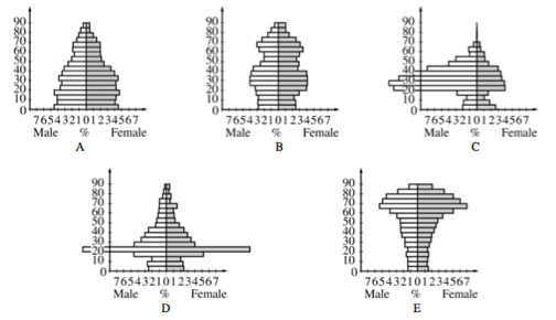
|
02 | 01 |
| agglomeration economies |
Benefits or advantages resulting from the spatial clustering of activities and/or people. In general, agglomeration economies are cost-reducing factors to businesses. An simple example would be locating a business in town rather than in an outlying area because access to electricity, communications, water and sewer, roads, and other infrastructure is available in town but would have to be built in the outlying area. More complex examples involve service work and markets for goods and services.
07-2013APEXAMMCQ#1B-agglomeration-image 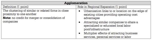
Agglomeration is also an important concept in Topic 7 (urban land use). It's the reason why downtown "central business districts" exist, as well as manufacturing operations, artist's communities, residential neighborhoods and so on. A related concept is density. |
06 | 07 |
| agrarian | People or societies that are farmers. Agrarian people and societies are located away fro cities in rural areas. In lesser-developed countries (LDCs) a majority or significant plurality of people may be subsistence farmers. In developed countries (MDCs), less than 3% of the population may be farmers. In developed countries, for example, a specialized, highly productive 3% of the population feeds 97% of the population. | 05 | |
| agribusiness | Commercial agriculture characterized by integration of different steps in the food-processing industry, usually through ownership by large corporations. | 05 | agricultural density | The number of farmers per unit area of farmland. | 02 | 01 |
| agricultural industrialization (or mechanization) | The use of machinery in agriculture, like tractors, automated irrigation equipment, and so on. Agricultural industrialization lowers agricultural density (the number of farmers per land are unit). | 05 | |
| agricultural labor force | The number of people who work in agriculture. A large value indicates that the country is likely an LDC dependent on agriculture, while a small value indicates that there are fewer people working in agriculture, meaning that the agriculture is mechanized and efficient. | 06 | |
| agricultural landscape | The rural land that is farmed or ranched. | 05 | |
| agricultural location model | See von Thunen (or Isolated State) Model. | 05 | |
| agricultural origins | Over time, ancient nomadic people noticed the growing of plants in a cycle and began to domesticate them and use for their own use. For a much more detailed description of the origins of agriculture, see the lecture notes from Jared Diamond's book "Guns, Germs, and Steel". | 05 | |
| agricultural revolution | Approximately 10,000 years ago, humans first began to plant seeds and domesticate animals. This allowed for nomadic bands, clans, and tribes to settle in one location, or to seasonally migrate between one of a few settlement locations (a practice called transhumance). | 02 | 05 |
| agriculture | The deliberate effort to modify a portion of Earth’s surface through the cultivation of crops and the raising of livestock for subsistence or economic gain. | 05 | |
| air pollution | A concentration of trace substances (toxins or particulate matter) from the emissions of motor vehicles, industry, and power plants. | 06 | |
| aluminum industry | US companies are the largest single producer of aluminum with plants in 35 states producing over 1.5 million tons for domestic consumption and for export. U.S. supply is comprised of both primary (extraction) and scrap (recycled). Producing aluminum is energy intensive. | 06 | |
| Amazon River Basin | PG | 05 | |
| animal domestication | Domestication of animals for direct consumption as a source of protein and fat, and also for so-called "byproducts": hide (leather), sinew and gut (lacing), bone (buttons, dice), horn (buttons, dice, eyeglass frames and tool handles), and so on. | 05 | |
| animism | Belief that objects, such as plants and stones, or natural events, like thunderstorms and earthquakes, have a discrete spirit and life. This is important to Human Geography because a lot of cultures around the world believe in Animism | 03 | |
| annexation | Incorporation of a territory into another geo-political entity. | 04 | |
| Antarctica | Southernmost continent in the world. It has no permanent residents and by international agreement cannot belong to any country. | 04 | |
| antecedent boundary (border) | A boundary that was created before the present day political-cultural landscape developed. | 04 | |
| Apartheid | The Afrikaans (Dutch-origin language of South Africa) for apartness, it was the legal system of segregation of blacks in South Africa from 1948 to 1994. It was created to keep the white minority in power and allow them to have almost total control over the black majority. | 04 | |
| aquaculture (also, mariculture) | The cultivation of aquatic organisms especially for food. | 05 | |
| Area Studies Tradition | From WD Pattison's Four Traditions of Geography:
|
02 | 01 |
| arithmetic density | The total number of people divided by the total land area. This is what most people think of as density; how many people per area of land. | 02 | 01 |
| assimiliation | Process by which people completely adopt a new culture. This occurs when people migrate from one cultural region to another, or when a dominant cultural trait diffuses to a new area. By contrast, see acculturation. | 03 | |
| Baby Boom | People born in the US between 1946 and 1964, the generation that followed World War II. In the immediate post-war era, the US Congress passed a number of laws to provide for support for education and housing (the GI Bill), and employment (the Employment Act of 1946). These programs led to higher rates of both marriage and fertility. | 02 | 06 |
| baby bust | A period in the US during the 1960s and 1970s when fertility rates dropped as many female baby boomers sought higher levels of education and jobs, marrying later in life. | 02 | 06 | Balkanization | The political term used when referring to the fragmentation or breakup of a region or country into smaller regions or countries. The term comes from the Balkan wars, where the country of Yugoslavia was broken up in to six countries between 1989 and 1992. It was the effect of the Balkan wars. | 04 | Balkan peninsula | PG |
| barriada | A neighborhood, usually a slum or dilapidated lower SES (socio-economic status) ethnic community— typically encircles large cities of Latin America. | 07 | 01 |
| basic demographic equation | See demographic equation. | 02 | 01 |
| bid rent theory |
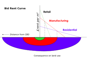
source: wikipedia |
07 | 06 |
| biorevolution | The revolution of biotechnology and the use of it in society. | 05 | |
| biotechnology | Using living organisms in a useful way to produce commercial products like pest resistant crops. | 05 | |
| blockbusting | A notorious practice in the real-estate profession to prod white families to sell their homes in fear that blacks would move into the neighborhood and lower the property value. This practice was widely responsible for "white flight" from the 1950’s and the growth of suburbs. White home owners were encouraged to quickly sell their houses at below-market prices by agents who then sold the property to black Americans at higher-than-market prices. Since black people usually did not qualify for mortgages from banks and savings and loan associations (see "redlining"), they used a land installment contract instead, which offered less legal protection from foreclosure than a standard mortgage and loan agreement. | 07 | |
| border landscape | Literally the geographical area that is divided by a border between states. There are two types, exclusionary and inclusionary. Exclusionary is meant to keep people out, such as the border between the U.S. and Mexico. Inclusionary is meant to facilitate trade and movement, such as the US-Canada border or the borders between the member states of the European Union (EU). | 04 | |
| borneo | Island in Southeast Asia politically divided among three countries: Malaysia and Brunei in the north, and Indonesia to the south. Approximately 73% of the island is Indonesian territory. In the north, the East Malaysian states of Sabah and Sarawak make up about 26% of the island. Additionally, the Malaysian federal territory of Labuan is situated on a small island just off the coast of Borneo. The sovereign state of Brunei, located on the north coast, comprises about 1% of Borneo's land area. Borneo is noteworthy today for the deforestation of its rain forests, some of the oldest in the world, and the disruption of native cultures. | PG | |
| Boserup, Ester | By contrast to Thomas Malthus and contemporary neo-Malthusians, Danish economist Ester Boserup argued that human population growth stimulates agricultural intensification: "…the power of ingenuity would always outmatch that of demand…". In other words, using the full spectrum of technological improvements (agronomy, mechanization, preservation and transportation, for example) people will always be able to provide necessary food resources. | 02 | 06 |
| boundary | A line, whether along a geographical feature or along a geometric line that separates one territory from another. Boundaries are different from borders in the sense that boundaries are generally within the borders of a country (a state) and separate the country into sub-units like states, counties, municipalities, and so on. | 04 | |
| Boundary, disputes (definitional, locational, operational, allocational) | 04 | ||
| Boundary, origin (antecedent, subsequent, superimposed, relic) | 04 | ||
| Boundary, process (definition, delimitation, demarcation) | 04 | ||
| Boundary, type (natural/physical, ethnographic/cultural, geometric) | 04 | ||
| break-of-bulk point | A location where transfer is possible from one mode of transportation to another. | 06 | |
| Buffer state | 04 | ||
| Buddhism | The third of the world’s major universalizing religions. It has over 350 million followers especially in China and Southeast Asia. | 03 | |
| building material | Houses and other structures are typically built from materials that are abundant in the area. | 03 | |
| built-up space | The built-up space, meaning buildings and infrastructure of a place; usually associated with a central city and suburbs, but can pertain to any man-made structures or objects. See also, cultural landscape. | 07 | 01 |
| calorie consumption | Calorie consumption as a percentage of daily requirement is an important index of development. People in MDCs generally consume more than 130% of their daily requirements, but most people in LDCs barely get enough to sustain themselves. | 06 | |
| capital | 04 | ||
| cargo cult Pilgrimage | Cargo cults believe western goods have been traded to them by ancestral spirits. It is common in Melanesia (Pacific Realm) as a religious movement. | 03 | |
| carrier efficiency | Each type of transportation has a net cost per unit transported. The goal is to find the least costly (most efficient) means to transport something. | 06 | |
| carrying capacity | The population level that can be supported, given the quantity of food, habitat, water and other life infrastructure present. | 02 | 05 |
| catalysts of migration | Economic conditions, political circumstances, armed conflict & civil war, environmental conditions, culture and traditions, technological advances, flow of information (through technology) that cause emigration or immigration. See pull factors and push factors. | 02 | 06 |
| census tract | An area of approximately 5,000 people that is designated by the US Census Bureau for the purposes of counting and reporting on the US population. In general, census tracts are small and correspond to neighborhoods inside cities, but can be much larger in the countryside where population density is lower. Census tracts are generally the smallest unit for which comprehensive population statistics are available. | 07 | |
| central business district (CBD) | A central business district (CBD) is the location of tall buildings (skyscrapers) that house major service-sector firms. Almost all of the people who work in the CBD commute; few people actually live there. It is generally the location of the most expensive real estate in a city. | 07 | |
| centrality | The strength of dominance of an urban center over its surrounding area. Some cities dominate an Metropolitan Statistical Area (MSA); other MSAs do not have a single, dominant city but have multiple centers. | 07 | |
| centralization | The movement of people, capital, services, and government offices into the central city. Also called "urbanization", it is the opposite of today’s suburban sprawl and generally took place before WWII. In some areas of the US and other developed countries, there has been a trend toward centralization with gentrification. | 07 | |
02-2006APEXAMFRQ#3B-image.png
|
04 | ||
02-2006APEXAMFRQ#3B-image2.png
|
04 | ||
| census | A periodic (official) count of a country's population—in the US, for example, the federal government conducts a census every 10 years ("denial") as required by the US constitution. The Constitution required the census to reallocate seats in the House of Representatives (a process called reapportionment). | 02 | 04 |
| census tract | An defined area, usually representing a neighborhood, established for the purpose of conducting a census. It is defined to provide meaningful demographic data at the smallest scale. | 02 | 04 |
| chain migration | A migration event in which individuals follow the migratory path of preceding friends or family to an existing community (initial migration created a “chain reaction”). One result is an ethnic enclave, such as a Chinatown. In South Florida, examples include Little Havana, Little Haiti, and more recently, Sunny Isles (ethnic Russian). | 02 | 06 |
| child mortality rate | See Infant Mortality Rate (IMR) | 02 | 01 |
| Christaller, Walter | Developed Central Place Theory, which attempts to explain how services are distributed and why there are distinct patterns in this distribution (central place theory involves market area/hinterland and the threshold/range, which is the minimum number of customers needed to keep the business running). | 07 | |
| Christianity | A monotheistic religion centered on the life and teachings of Jesus of Nazareth as presented in the New Testament. | 03 | |
| city | A centralized area with a local government that provides a full set of services within its boundaries. It is bigger than a town, but smaller than a metropolis. | 07 | |
| cityscape | Similar to a landscape, but in an urban setting. A cityscape is often compared to a skyline, but it also includes features at smaller scales, down to neighborhoods and even single streets that may or may not exhibit a similarity to other city streets. | 07 | |
| city-state | 04 | ||
| clustered | See density. | 01 | 01 |
| cohort | Population of various age categories in an age-sex population pyramids. This is important because this can tell what state this country it is whether in Stage 3 or Stage 5 in the demographic transition model. | 02 | 01 |
| collective farm | A system of agricultural organization where farm laborers are not compensated via wages, but by receipt of a percentage of the farm's net productivity. | 05 | |
| colonialism |
An era of history stretching from the 16th century until the present, during which a technologically and militarily dominant nation of people assert absolute control over another nation of people to exploit that nation's resources for their sole, maximized, gain. Commercial and military competition among dominant nations drives those nations to seek the most efficient means of economic and technological growth; to do so, they are compelled to seek ever less expensive resources through militaristic and social policies of oppression over their colonial possessions.
The era of colonialism coincides with Thomas Friedman's "Globalization 1.0" and Treaty of Westphalia (1648) which many point to (including Immanuel Wallenstein's World Systems Theory). |
04 | 01 |
| colonial city | Cities founded by colonial powers, such as Mexico City by the Spanish. Colonial cities often feature large plazas, Catholic or protestant cathedrals, and historic architecture, most of these are in Latin America, Africa, and South and East Asia. | 07 | |
| commercial agriculture (intensive, extensive) | Agriculture undertaken primarily to generate products for sale off the farm. | 05 | |
| commercialization | Creating a for-profit business enterprise—generally from something that to that point has not been to that point something that is sold. An example would be bottled water. | 07 | |
| commodity chain | The series of links connecting places of extraction, production, and distribution in the world market. | 06 | |
| compact state | States (countries) where the distance from its geographic center, to any point on the boundary does not vary greatly. In most cases, this enables efficient transportation and communication for government, commerce, and people. | 04 | |
| comparative advantage | The ability of an individual, firm, or country to produce a good or service at a lower cost than other producers. | 06 | |
| concentration | See |
01 | 01 |
| Concentric Zone Model |

Created by E.W. Burgess, a city grows outwards from a central area in a specific pattern of nested rings: CBD in middle, then zone of transition, then zone of workers’ homes, then zone of residences, then commuter’s zone. |
07 | |
| Conference of Berlin (1884) | 04 | ||
| Confucianism | Developed by earlier Chinese man Confucius, it’s a complex system of moral, social, political, and religious thought. This is important to HG because it has affected Chinese Civilizations tremendously. | 03 | |
| connectivity | The relationships among people and objects across the barrier of space. Geographers are concerned with the various means by which connections occur. | 01 | 01 |
| constitutional democracy | 04 | ||
| Core-Periphery Model |
Describes the pattern of distribution of the MDCs and LDCs. When the earth is viewed from the North Pole, the MDCs are clustered near the center of the map while the LDCs are near the edges.
The Core-Periphery Model is associated with a number of geographers and economists. Wallerstein's World Systems theory is the most contemporary of these theories. |
04 | 06 |
| counter migration | Migration back to an original area from which people emigrated. Examples include emigration due to natural disasters or military conflict. | 02 | 04 |
| counterurbanization | Net migration from urban to rural areas. This only happens in very developed areas in North America and Western Europe) | 07 | |
| crop rotation | The practice of rotating use of different fields from crop to crop each year, to avoid exhausting the soil. | 05 | |
| Crude Birth Rate (CBR) | The ratio of live births in an area to the population of that area; it is expressed as number of birth in year to every 1,000 people alive in the society. | 02 | 06 |
| Crude Death Rate (CDR) | The ratio of deaths in an area to the population of that area; it is expressed as number of deaths in year to every 1,000 people alive in the society. | 02 | 06 |
| Crude Population Density | The mathematic relationship between the population of a land area and the size of that land area in any space, usually expressed in persons per square mile or persons per square kilometer. See also: arithmetic density and physiological density. | 02 | 01 |
| cultivation regions | Areas were specific types of commercial agriculture are practiced (e.g. wheat belt, corn belt, fruits, vegetables, ranching, cut flowers, and so on.) | 05 | |
| cultural convergence | The change in culture that occurs as diffusion of ideas and technology increases. An example is the culture of LDCs becoming more like that of their former colonial power (an MDC). Related terms are acculturation and transculturation. | 06 | |
| cultural ecology | Geographers use the term cultural ecology to describe all of the relationships between a culture and its environment. It includes all of the following:
|
01 | 03 |
| cultural identity | Belonging to a group with a certain level of acceptance of the beliefs and behaviors prevalent within that group. | 03 | |
| cultural landscape | A combination of cultural features such as language and religion, economic features such as agriculture and industry, and physical features such as climate and vegetation. (defined by Carl Sauer as an area fashioned from nature by a cultural group) | 01 | 03 |
| cultural-political boundary (border) | A political boundary that separates different cultures. Generally, these are the borders of nation-states in the developed world (Europe, South America, Southeast Asia). Can also refer to devolution or fragmentation within countries, the former Yugoslavia or the Czech and Slovak republics. | 04 | |
| cultural realm | A large geographic area where the people share a set of cultural beliefs and behaviors. In APHG we recognize 12 such realms:
|
03 | |
| cultural realm | A geographic area within a cultural realm where the people share a set of cultural beliefs and behaviors with those in the larger realm yet have a significant set of differences. In APHG we recognize 12 realms, but within each, there can be a number of different regions. For example, in Europe, we recognize the following regions:
|
03 | |
| culture | The body of customary beliefs and behaviors (social norms that we call artifacts, menti-facts, and socio-facts) that together constitute a distinct group of people and a distinct tradition or history. | 03 | |
| cumulative causation | A process through which economic growth is self-reinforcing; an expression of agglomeration and the multiplier effect, economic growth tends to favor major cities and core regions over less-advantaged peripheral regions. | 06 | |
| cyclical movement | Movement that has a closed route and is repeated annually or seasonally (e.g., activity (action) space – space within which daily activity occurs; commuting, seasonal, nomadism). | 02 | 06 |
| dairying | The “farming”, sale, and distribution of milk and milk products. | 05 | |
| debt-for-nature swap | When agencies such as the World Bank make a deal with third world countries that they will cancel their debt if the country will set aside a certain amount of their natural resources. | 05 | |
| decentralization | Dispersing decision-making outwards from the center of authority. See also, devolution. | 07 | |
| deglomerization | The process of industrial de-concentration in response to technological advances and/or increasing costs due to congestion and competition. | 06 | |
| deindustrialization | Social and economic changes caused by a transition from a manufacturing-based economy to a service-based economy. Companies move industrial jobs to other regions with cheaper labor, leaving the newly de-industrialized region to switch to a service economy and to work through a period of high unemployment. A related term for these changes is a "post-industrial" economy. | 06 | |
| demographic equation (basic demographic equation) | The formula that calculates population change without including net migration.
CBR - CDR = NIR (excludes net migration) The formula finds the increase (or decrease) in a population. The formula is found by doing births minus deaths plus (or minus) net migration. This is important because it helps to determine which stage in the demographic transition model a country is in. |
02 | 01 |
| decolonization | 04 | ||
| demographic momentum |
When a population has recently dropped below replacement-level fertility (TFR = 2.0, as a generality) the population will continue to grow because there are still a large number young people who have yet to reach their childbearing years. it can take several generations for a population to achieve a demographic balance that yields a very small growth rate (NIR=1.0%), zero population growth (ZPG) or, even, a negative growth rate which corresponds to Stage 4 of the Demograpic Transition Model and is graphically depicted as a columnar age distribution graph (population pyramid).
Note: this concept was demonstrated clearly by Hans Rosling in the Don't Panic documentary. Other terms for this include: population inertia or population-lag effect. This time-lag effect is of great importance to the growth rates of human populations. |
02 | 06 |
| demographic regions | World cultural realms and world cultural regions generally feature nations and countries that share similar conditions predicted by the Demographic Transition Model. | 02 | 01 |
| Demographic Transition Model (DTM) |
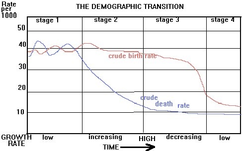
A graphic representation of population for an area that plots the Crude Birth Rate and Crude Death Rate on one graph. Stage 1 is low growth, Stage 2 is High Growth, Stage 3 is Moderate Growth, and Stage 4 is Low Growth. Some models present a Stage 5, which represents a period of zero or negative population growth experienced by post-industrial populations. Note that the area between the CBR and CDR curves represents the Natural Increase Rate. |
02 | 06 |
| demography | The geographic study of population. | 02 | 01 |
| density | The frequency with which something occurs in space (can be measures of people, houses, cars, volcanoes, or anything, with any method of measurement). See also, arithmetic density, physiological density. | 01 | 01 |
| dependency ratio | The number of people who are too young or too old to work compared to the number of people in their productive years. This is important because this tells how many people each worker supports. For example the larger population of dependents, the greater financial burden on those who are working to support those who cannot.
LDCs tend to have a higher dependency ratio, the ratio of the number of people under 15 or over 64 to the number in the labor force. |
02 | 06 |
| Dependency Theory | Dependency theory is the notion that resources flow from a "periphery" of poor and underdeveloped states to a "core" of wealthy states, enriching the latter at the expense of the former. It is a central contention of dependency theory that poor states are impoverished and rich ones enriched by the way poor states are integrated into the "world system". | 06 | |
| determinism | See environmental determinism. | 01 | 05 |
| development | The improvement in material conditions of a place as a result of diffusion of technology and knowledge. It is a main goal for most of the planet’s regions and development will help solve many problems; it will create many problems, too. | 06 | |
| devolution | The statutory (law) granting of powers from the central government of a state (country) to government at a lower level. The higher level government entity passes a law granting additional powers to the lower government.
It differs from federalism in that the powers devolved may be temporary and ultimately reside in central government, thus the state remains, de jure, unitary. Any devolved parliaments or assemblies can be repealed by central government in the same way as an ordinary statute can be. Federal systems, differ because the sub-national government is guaranteed its existence by the national constitution. Devolution can be mainly financial, granting the sub-national government its own tax base and budget, or it can be cultural, meaning that the sub-national entity is primarily concerned with preserving some aspect of its unique local culture. It can also refer to the fragmentation of a state. See also, decentralization, Balkanization. |
04 | |
| diffusion | The process by which a cultural attribute, such as language and religion, economic features such as agriculture and industry spreads, or ideas, such as architectural styles or political practices, move from one place to another over time.
In APHG, you'll need to know that there are several types of diffusion geographers refer to when describing the distribution of phenomena across space:
Related concepts include: hearth (cultural hearth), sequent occupance, innovation adoption (technology transfer), and maladaptive diffusion (diffusion of something with negative side effects—what works well in one place may not in another. |
01 | 03 |
| direction | Compass headings, typically, are used to give directions. There are two types: cardinal (North, South, East, West) and ordinal (NE, SE, SW, NW, but also, points in between such as North-North-East). Each is associated with the degrees of rotation in the unit circle (North = 0°, South = 180°, South East = 135° South-South-West = 202.5°:), Global Positioning Satellite (GPS) Receivers use trigonometry to calculate direction, and use time to calculate distance traveled, estimated distance to a destination.
Relative location is frequently expressed using direction. |
01 | 01 |
| disease diffusion | There are two types, contagious and hierarchical. Hierarchical is along high density areas that spread from urban to rural areas. Contagious is spread through the density of people. This is important in determining how the disease spread so you can predict how it will spread. | 02 | 06 |
| dispersion | See density. | 02 | 06 |
| distance decay |
01-2008APEXAMMCQ#19-image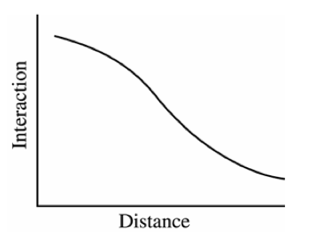
As seen in the graph above, which was taken from the 2008 APHG Practice Exam (MCQ#19), as distance increases, interaction decreases—there is an inverse relationship between distance and interaction. In APHG, interaction (and influence) diminishes, and eventually disappears as something diffuses its origin. Typically, the farther away one group is from another, the less likely the two groups are to interact, however, improvements in transportation technologies and communications technologies are connecting places "virtually" to overcome barriers to interaction over long distances. See also, friction of distance. |
01 | 03 |
| distribution | The arrangement of something across Earth's surface; it is one of the fundamental concepts in APHG. It pertains to the arrangement of earthforms, flora and fauna, as well as people and man-made objects in any space. Density, concentration, and pattern are related concepts. | 01 | 01 |
| division of labor |
Division of labour is the specialisation of cooperative labour in specific, circumscribed tasks and roles, intended to increase the productivity of labour. Historically the growth of a more and more complex division of labour is closely associated with the growth of total output and trade, the rise of capitalism, and of the complexity of industrialisation processes. Later, the division of labour reached the level of a scientifically-based management practice with the time and motion studies associated with Taylorism.
Productivity gains from the division of labor are important in any type of production process, ranging from simple extraction sector work to sophisticated computer software production to legal work, finance, and medical care. The division of labor makes trade necessary and is the source of economic interdependence. |
06 | |
| domino theory | 04 | ||
| double cropping | Harvesting twice a year from the same land. Can cause soil depletion. See also, crop rotation. | 05 | |
| doubling time | The number of years needed to double a population, assuming a constant rate of natural increase. It is approximated by taking the percentage growth as a whole number (e.g. 2% = 2.0) and dividing that number into 70. By this formula, a 2% rate of population increase would result in a doubling time of 35 years (70 ÷2=35). An important inference is that a doubling of population also means a doubling of infrastructure and resource usage. | 02 | 06 |
| early city | Cities of the ancient world (3500 - 1200 bce), generally located in the Fertile Crescent, and several river valleys (Nile, Indus, and so on). | 07 | |
| Earth-Science Tradition |
From WD Pattison's Four Traditions of Geography:
|
01 | 01 |
| economic base | The collection of industrial sectors (primary, secondary, tertiary) that an area, city, or region relies upon for its income. | 07 | |
| economic sector | The classical breakdown of all economic sectors follows:
|
06 | 01 |
| ecumene | The area of Earth's surface occupied by permanent human settlement. See also, built up space. | 01 | 02 |
| edge city | A new concentration of business in a suburban area. In many cases, these areas are in the process of becoming second cities as described by the Multiple-Nuclei Model. | 07 | |
| electoral regions | 04 | ||
| elongated state | A state (country) that is geographically long and narrow. This can make transportation and communications more difficult than in compact states. | 04 | |
| emerging citiy | A city undergoing rapid population growth that was formerly smaller and isolated. | 07 | |
| employment structure | An analysis of the kinds of work (jobs) done in an economy. In general, this data is presented by economic sector (primary secondary and tertiary). | 07 | empty-nester | Parents of grown children who have left to live on their own. Typically older, these people seek to "downsize" their home in urban or suburban areas to reduce maintenance work or costs (gardening, cleaning, and so, on) | 07 |
| enclave/exclave | A enclave is a country or part of a country mostly surrounded by the territory of another country; an exclave is one which is geographically separated from the main part by surrounding alien territory. Armenia is a good example of an enclave and Kaliningrad (Russia) is a good example of an exclave. | 04 | |
energy consumption | One index (measure) of development. MDCs tend to consume much more energy per capita than do LDCs. As LDCs industrialize, there will be greater demand for energy from the world's supply. | 06 | |
| entrepot | A city that serves as a trade center where goods are exported and imported. See also, port city, gateway city. | 07 | |
| environmental determinism | A 19th and early 20th century approach to the study of geography that argued that the general laws sought by human geographers could be found in the physical sciences. Geography was therefore the study of how the physical environment caused human activities. | 01 | 01 |
| environmental modification | The destruction of the environment by agricultural production. Pesticide and fertilizer use pollutes bodies of water, rivers, and underground water sources. Overuse of land causes desertification. Irrigation drains bodies of water and rivers, and depletes ground water stores. Note that the level of the Dead Sea is falling because of over tapping of the Jordan River; the Colorado River no longer reaches the Pacific Ocean; the Ural Sea and Lake Chad are disappearing. | 05 | |
| epidemiological transition (model) |
In the AP Human Geography course, the epidemiological transition should be considered as one of the factors undergird the Demographic Transition Model): a medical innovation (disease or sickness treatment) that is either discovered or transferred to a population causes that population’s Crude Death Rate to fall.
On a global scale, an epidemiological transition occurred when advancements in antibiotic research in the mid-twentieth century (notably the production of penicillin) were shared widely. This led to a drop in deaths caused by infectious diseases. The epidemiological transition model proposed by Abdel Omran in 1971 suggested that there is a distinct cause of death in each stage of the demographic transition model: for example, typical causes of death for each of the stages of the Demographic Transition Model include the following: Stage 1=Black Plague, Stage 2=Cholera, Stage 3=Chronic disorders, 4= natural causes (old age). |
02 | 06 |
| ethnic conflict | 04 | ||
| ethnic neighborhood | A neighborhood with distinctive ethnic composition. In most cases, these areas resulted from chain migration as well as a history of discrimination or segregation. | 07 | |
| ethnic religion | A religion whose membership is predominantly of one ethnicity and that one is born into. Judaism, Shintoism, and Hinduism are good examples of ethnic religions. As a result, these religions tend to be concentrated rather than dispersed. | 03 | |
| European Union | 04 | ||
| Exclusive Economic Zone (EEZ) | 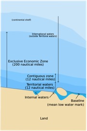
|
04 | |
| expansion diffusion | The spread of a feature from one place to another in a snowballing process. This can happen in 3 ways:
|
01 | 03 |
| exponential growth | Numerical growth, as in population growth, that increases by an exponent. For example n^2 increases 2, 4, 8, 16, … | 02 | 01 |
| extensive subsistence agriculture | See shifting cultivation and, nomadic herding/pastoralism | 05 | |
| factors of location | The costs that are considered when deciding where to locate a capital (a home, a business, infrastructure). Some costs are transportation, labor, agglomeration, market, energy, terrain, climate, personal preference, the product itself. | 06 | |
| factors of production | Capital, entrepreneurship, land, and labor (CELL); the resources that are used to make all goods and services. Money is exchanged for each in an economy: wages for labor, interest for capital, profit for entrepreneurship, and rent for land (WIPR). | 06 | |
| favela | A shantytown or slum, especially in Brazil. | 07 | 06 |
| federal | 04 | ||
| feedlot | Also called a Concentrated Animal Feed Operation (CAFO), it is a plot of land on which livestock are corralled and fattened before slaughter. CAFOs are controversial because of the amount of urine and feces they produce and the fact that the animals live in poor conditions (waste is not typically disposed of until the CAFO is cleared for slaughter). | 05 | |
| female-headed household | A household with a woman as the sole, or largest, income earner. | 06 | |
| fertility rate | The number of children born to a woman during her lifetime, generally assumed to be from age 15 to age 35. It is measured as the number of children per woman with zero being a low figure and 8 being high. Zero population growth occurs somewhere around 2.1 children per woman. In the U.S it's below 2.1 in much of Africa it is above 4, if South America is between 2 and 3, in Europe it is below 2.1, in China and Russia it is below 2.1, and in much of the Middle East it is above 4. | 02 | 01 |
| festival landscape | The landscape of occasional or regular cultural festivities. | 03 | |
| forced migration |
People removed from their countries and forced to live in other countries because of war, natural disaster, and government policy such as the Atlantic slave trade, Jewish Diaspora, and post-WWII population shifts.
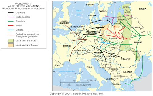
| 02 | 04 |
| fishing/fishery | Catching fish and other marine and freshwater organisms as an extraction sector activity. Fishing provides a food source and employment. | 05 | |
| food chain | A series of organisms interrelated in their feeding habits, the smallest being fed upon by a larger one, which in turn feeds a still larger one, and so on. | 05 | |
| Fordism |
Fordism merely means assembly line production, or the industrial arrangement of machines, equipment, and workers for continuous flow of work pieces in mass production operations, each movement of material is made as simple and efficient as possible. Named for Henry Ford, though he did not actually invent the system.
Closely associated with Fordism is the older, more fundamental concept of "interchangeable parts" and, later, industrial standards, industrial engineering, and supply-chain management. |
06 | |
| foreign direct investment | The purchase or construction of capital resources in one country using money that originates in another country. Generally, in APHG, we are concerned with the investment in LDCs by transnational (or multinational) corporations based in MDCs. | 06 | |
| forestry | The science of planting and taking care of trees and forests. Trees provide building materials, paper, and fuel. It is a primary sector activity. Also called "timbering". | 05 | |
| formal region | A uniform or homogenous region is an area within which everyone shares in common one or mare distinctive characteristics. The shared feature could be a cultural value such as a common language, or an environmental climate. | 01 | 01 |
| fortified boundary (border) | When a state constructs physical barriers along a boundary to either keep people in or out of their territory. The Great Wall of China (which is also a relict boundary), the Berlin Wall (again, all a relict boundary), earthen berms along the Morocco/Spanish Sahara border are examples of a fortified boundary. | 04 | |
| forward capital | 04 | ||
| fragmented state | A state (country) split into many pieces. Also called an "insular" state. The Philippines and Indonesia are good examples of fragmented states. | 04 | |
| friction of distance | Distance usually requires some amount of effort, money, and/or energy to overcome. Because of this "friction," spatial interactions will tend to take place more often over shorter distances; quantity of interaction will decline with distance. | 01 | 01 |
| frontier | A area within a nation-state where little or no government control is present due to the remoteness of the location and the sparseness of the population. Large parts of the American West could still be considered frontier zones, but better examples exist in many under-developed countries. | 04 | |
| frontier zone | A area, generally a border zone, where no state exercises political control due to the remoteness of the location and the sparseness of the population. Antarctica, for example, and portions of Saudi Arabia are examples of frontier zones. | 04 | |
| functional (or nodal) region | Area organized around a node or focal point. The characteristic chosen to define a functional region dominates at a central focus or node and diminishes in importance outward. This region is tied to the central point by transportation or communication systems or by economic or functional associations. | 01 | 01 |
| fundamentalism | Literal interpretation and strict adherence to basic principles of a religion. | 03 | |
| gateway city | A city which acts as a link between two areas. | 07 | |
| gender | A person's sex. | 03 | 01 |
| gendered space | An area that is exclusive to one gender, for example, a women's restroom, an all-male school. Closely related to the concept of gendered space are cultural norms and taboos | 01 | 03 |
| gender equality | Gender equality is the is the view that men and women should receive equal treatment, and should not be discriminated against based on gender. It is an objective of the United Nations Universal Declaration of Human Rights, which seeks to create equality in law and in social situations, such as in democratic activities and securing equal pay for equal work. A great difference in development between the genders is found primarily in LDCs, especially in the Middle East. Important measures include income and in literacy rate. | 06 | |
| Generation X | People born in the US between 1965 and 1980; will have the burden of supporting the Baby Boom cohort as they head into retirement. | 02 | 06 |
| Generation Y | people born between 1980 and 2001; also referred to as "Echo Boomers" (many are the offspring of Baby Boomers). | 02 | XX |
| gentrification | The process by which low cost neighborhoods are renovated to increase property values. Criticism of gentrification generally focuses on the fact that increases in property values will mean that poor people will be forced to leave the neighborhood. | 07 | |
| geomancy | A method of prediction that interprets markings on the ground, or how handfuls of dirt land when someone tosses them. An Arabic tradition consists of sketching sixteen random lines of dots in sand. | 03 | |
| geometric boundary (border) | Straight lines that serve as political boundaries and are unrelated to physical and /or cultural differences, ie. United States/Canadian border west of the Great Lakes, many of Africa’s borders, and the borders of western US states use geometric boundaries. | 04 | |
| geopolitics | 04 | ||
| gerrymander | 04 | ||
| ghetto | A poor section of a city inhabited primarily by people of the same race, ethnicity religion, or social background. (See also: barriada, favela). | 07 | 03 |
| GIS (Geographic Information System) | GIS is an electronic mapping system that incorporates "layers" of information that can be superimposed over a landscape. A good example is Google Earth's features for place names, transportation lines, and so on. These can be switched on and off to show different information about the same area. | 01 | 04 |
| global commons | 04 | ||
| globalization | Increasing interactions among the world's people due to improvements in transportation and communications technologies. Recall Thomas Friedman's "three great eras of globalization: Globalization 1.0 (countries), 2.0 (companies), 3.0 (individuals). Compare these to Immanuel Wallerstein's "World Systems Theory". | 01 | 06 |
| GNIS (Geographic Names Information System) | Geographic Names Information System (GNIS) is a database that contains name and locative information about more than two million physical and cultural features located throughout the United States of America and its territories. | 01 | 04 |
| GPS (Global Positioning System) | Originally 24 satellites in geo-synchronous orbit (now there are many more) that transmit radio signals to GPS receivers on Earth (such as a Garmin automobile navigation device). Contact with any four satellites allows the device to calculate its absolute location with a margin for error of approximately one meter. | 01 | 06 |
| Gravity Model (Reilly) | Inspired by the law of gravitation between physical bodies of mass, social "bodies" are also theorized to influence one another as a function of the distance between them. Here is a longer discussion of the concept that you'll need to summarize on your index card. It relates to migration in Topic 2 and retail store locations in Topic 6. | 06 | 02 |
| green revolution | The third "agricultural revolution" (following the neolithic agricultural revolution and late 19th century mechanization of agriculture), the ‘Green Revolution’ refers to the rapid diffusion of new agricultural techniques between 1970’s and 1980’s, especially new high-yield and hybrid seeds ("miracle seeds") and chemical fertilizers (nitrogen, phosphorus, and potassium. Has caused agricultural productivity at a global scale to increase faster than population growth. An example of hybridization is "miracle wheat seed” which produces a shorter and stiffer plant that is less sensitive to variation in day length, responds better to fertilizers, and matures faster. The "miracle rice seed" produced a plant that with larger quantities and larger sized grains. High-yield corn seeds have also been developed. | 05 | |
| Great Plains of the United States | PG | 03 | |
| grid (indexing grid) |
On a globe, the indexing grid includes all of the primary absolute location features available to describe every place on the surface of the Earth: North and South Poles, lines of latitude (parallel lines including the Tropic of Cancer and Tropic of Capricorn), equator, lines of longitude (meridians), prime meridian, international date line. Maps cannot include all of these features, or, if they do, they are compromised (for example, on a Mercator Projection, the North and South Poles stretch the entire length of the top and bottom of the map.
Another common indexing grid is shown below. Barcelona, for example, is located at "C-10". 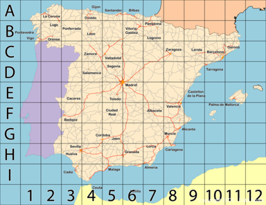
|
01 | 01 |
| gross domestic product (GDP) |
GDP is the total value of goods and services produced in a year in a given country—think of it as the total income of a country. The value varies greatly between MDCs and LDCs and is one of the best indicators of development. Increasing GDP is an important measure of economic development and economic growth.
Gross national product (GNP) is similar to GDP except that includes income that people earn abroad. (The distinction between GNP and GDP is generally not important in APHG.) |
06 | |
| growing season | The time period (usually a season) in which crops grow best in a given area. Growing season can vary by location, societies are confined by the growing season. | 05 | |
| Hajj | The pilgrimage to Mecca for Muslims and the fifth of the Five Pillars of Islam. All Muslims who are physically an financially able must take part in the Hajj at least once in their lives. | 03 | |
| hearth | The region from which innovative ideas originate. This relates to the important concept of the spreading of ideas from one area to another (diffusion). | 02 | 01 |
| heartland/rimland | 04 | ||
| Hinduism | An ancient religion of India, that today has approximately one billion followers. In general, the chief pursuit of Hinduism is to increase one’s karma by correct action. Reincarnation is a fundamental belief. | 03 | |
| homeostatic plateau | Population is equivalent to the carrying capacity of the occupied area. | 02 | 05 |
| Human Development Index (HDI) |
The Human Development Index is an aggregate index of development published by the United Nations (UN), which takes into account economic, social and demographic factors, using GDP, literacy and education, and life expectancy. Levels of development that countries are classified into include MDCs (more developed countries) and LDCs (less developed countries). Measures of development are used to distinguish LDCs from MDCs. They include GDP, literacy rate, life expectancy, caloric intake, etc.
The HDI is a specific measure on a scale of 1-100 that combines life expectancy at birth, adult literacy rate, gross school-enrollment ratio gross domestic product (GDP) per capita at purchasing power parity (PPP). Since 2010, the UN has changed the way it traditionally calculated HDI to more specifically express inequality and reports this new index as the "IHDI". This new measure uses more complex maths to calculate the index. You can find a discussion here: http://en.wikipedia.org/wiki/Human_Development_Index |
06 | |
| hunting and gathering | Before the neolithic agricultural revolution, humans obtained food by hunting for animals, fishing, or gathering plants. They lived in small groups (bands and clans—less than 50 people), and traveled frequently following game and seasonal growth of plants. | 05 | |
| immigrant states | 04 | ||
| Infant Mortality Rate (IMR) | (IMR) The annual number of deaths of infants under one year of age, compared with total live births. Its is expressed as the annual number of deaths among infants among infants per 1,000 births not a percentage (per 100). | 02 | 01 |
| intensive rice cultivation |
05-2008APEXAMMCQ#70-image
|
05 | 01 |
| intensive subsistence agriculture | A form of subsistence agriculture in which farmers must expend a relatively large amount of effort to produce the maximum yield from a parcel of land. Common in East, South, and Southeast Asia, because the ratio between farmers and arable land is so high, most of the work is done by the family by hand or by animal with processes refined over thousands of years. See also, intensive rice cultivation. | 05 | |
| interfaith boundaries | Boundaries between the world's major faiths, such as Christianity, Muslim, and Buddhism. Contrast with intra-faith boundaries, which describe the boundaries within a major religion such as the various populations within Protestantism in the US and Europe. | 03 | |
| International organization | 04 | ||
| Intertillage | A traditional practice of planting taller, stronger crops to shelter lower, fragile ones from tropical downpours. Little tending of the plants is necessary until harvest time, and no fertilizer is applied to the fields. The same clearings may be planted for four or five years until the soil loses it fertility. New fields are prepared and old fields may be abandoned for a long period of time. See also, shifting cultivation | 05 | |
| intervening opportunity | Presence of a nearer opportunity that diminishes the attractiveness of sites farther away. | 02 | 06 |
| Iron Curtain | 04 | ||
| irredentism | 04 | ||
| Islam | Literally translates as submission to the will of god. Its a monotheistic religion originating with the teachings of Muhammad, a key religious figure. It is the second largest religion in the world with 1.3 billion followers. It is the predominant religion of the Middle East from North Africa to Central Asia. Half of the world’s Muslims live in four countries outside the Middle East. Indonesia, Pakistan, Bangladesh, and India. | 03 | |
| Israel/Palestine conflict | 04 | ||
| J-curve | A forward-looking global population projection is sharply curved showing an increase in world population of many billions..9 billion, 12 billion, 16 billion? This is important because if the population grows exponential our resource use will go up exponential and so will our use as well as a greater demand for food and more. | 02 | 06 |
| Jainism | A religion and philosophy originating in ancient India. Stresses spiritual independence and equality throughout all life. | 03 | |
| Judaism | The religion of the ancient Hebrews and one of the first monotheistic faiths. | 03 | |
| karma | Means action, work or deed; it also refers to the principle of causality where intent and actions of an individual influence the future of that individual. Good intent and good deed contribute to good karma and future happiness, while bad intent and bad deed contribute to bad karma and future suffering. Karma is closely associated with the idea of rebirth in some schools of Asian religions.[5] In these schools, karma in the present affects one's future in the current life, as well as the nature and quality of future lives - or, one's saṃsāra. With origins in ancient India, it is a key concept in Hinduism, Buddhism, Jainism, Sikhism, and Taoism. (source: wikipedia) | 06 | |
| Kyoto Protocol | An international treaty, which extends the 1992 United Nations Framework Convention on Climate Change (UNFCCC) that commits State Parties to reduce greenhouse gases emissions, based on the premise that (a) global warming exists and (b) man-made CO2 emissions have caused it. Kyoto requires countries to reduce emissions of greenhouse gasses. Since these reductions generally increases costs to businesses and consumers there is significant political opposition to the Kyoto agreement in the US and other developed countries. (source: wikipedia) | 06 | |
| landlocked | 04 | ||
| labor union | An organization of workers that makes demands of an employer for higher wages, better working conditions, or better benefits such as health care or retirement savings programs. In the AP Human Geography course, you should see labor unions in the context of economic development strategy—for example, in your answer to 2006 FRQ #2, you could say in Part A that one reason why employers might want to locate businesses in small southern US towns is because labor unions are generally not part of the region's history and, therefore, employers do not face organized pressure to raise wages or provide other benefits that would be a higher cost to the business. See also, "efficiency wage". | 06 | 07 |
| language boundary (border) | A boundary that separates different language speakers. Traditionally many countries in Europe such as England, France, Spain, and Portugal established borders based on language. | 04 | |
| landlocked state | A state (country) not having direct access to an ocean. Bolivia and the Czech Republic are good examples of landlocked states. | 04 | |
| landscapes of the dead | Areas where people have commonly been buried and considered to be holy grounds not to be disturbed. | 03 | |
| latitude | The numbering system of concentric rings, or lines parallel to the Equator that are used to indicate the location north or south of the equator. The Equator is 0°locations north of the Equator are labeled "North Latitude"; locations south of the Equator are labeled "South Latitude". The North Pole is 90° North Latitude and the South Pole is 90° South Latitude. | 01 | 01 |
| Law of the Sea | 04 | ||
| Lebanon | 04 | ||
| levels of development | Countries are classified into MDCs (more developed countries) and LDCs (less developed countries). | 06 | |
| line of constant compass bearing | Depending upon what type of map is being used, lines of constant compass bearing may be either straight or curved. The chief advantage of a world map that has been prepared by Mercator Projection is the fact that straight lines (called rhumb lines) can be used in all directions and remain true for all lengths. | 01 | 01 |
| linear growth | Arithmetic growth; increasing at a constant amount per unit time. For example: n+1 increases 1, 2, 3, 4, …; n+2 increases 1,3,5,7,… By comparison, see exponential growth. | 02 | 01 |
| livestock ranching | Commercial grazing of livestock over an extensive area. Practiced is semi-arid or arid land, where vegetation is too sparse or the soil to too poor to support crops. Prominent in later 19th century in the American West; ranchers free roamed throughout the West, until the US government began selling land to farmers who outlined their farms with barbed wire and could by then use railroads to ship their livestock to slaughterhouses. | 05 | |
| location | See absolute location, relative location, site, situation, place, and toponym (place name). | 01 | 01 |
| long lot | A series of individual farmsteads (farms with homes) that are long and narrow, each of which are perpendicular along a river, so that each farm has river access. Typically found in France and colonial New England, including Canada. | 05 | |
| Mackinder, Halford J. | 04 | ||
| maladaptation | An adaptation that does more harm than good. | 02 | 06 |
| Malthus, Thomas | Was one of the first to argue that the worlds rate of population increase was far outrunning the development of food population. This is important because he brought up the point that we may be outrunning our supplies because of our exponentially growing population. | 02 | 06 |
| Man-Land Tradition |
From WD Pattison's Four Traditions of Geography (also called Human-Environmental, Human-Land, or Culture-Environment Tradition):
|
01 | 01 |
| Manifest Destiny | 04 | ||
| Manufacturing Belt of the United States | Also called the American Manufacturing Belt (or, in a negative sense, the "Rust Belt"), it is an area of the United States with a historical legacy of industrial manufacturing. Roughly, this industrial core area is bounded by Boston, Minneapolis, St Louis, and Baltimore. River canals, Great Lakes ocean freight, railroad transportation connected the mining of ores of Minnesota to the coal energy of the Appalachians This region for decades served as a magnet for immigrants from Austria-Hungary, Poland and Russia who provided the industrial facilities with the inexpensive labor resources | PG | 01F |
| market gardening | The small scale production of fruits, vegetables, and flowers as cash crops sold directly to local consumers. Distinguishable by the large diversity of crops grown on a small area of land, during a single growing season. Labor is done manually. | 05 | |
| Marxist geography | In the AP Human Geography course, Marxism shows up in political, economic, and social content. For example, the distribution of food today is market driven (equity), rather than command-based (equality): hunger is due to unequal distribution. With respect to population, unlike Thomas Malthus, Marxist principles place no limit on human population growth. | 06 | 02 |
| maternal mortality rate (MMR) |
The annual number of female deaths per 100,000 live births from any cause related to or aggravated by pregnancy or its management (excluding accidental or incidental causes).
|
02 | 06 |
| measures of development | Statistical measurements that are used to distinguish LDCs from MDCs. They include GDP, literacy rate, life expectancy, caloric intake, energy consumption, and so on. | 06 | |
| median-line principle | 04 | ||
| Mediterranean agriculture | Farming in the land surrounding the Mediterranean Sea (Southern Europe, North Africa, and Western Asia), also in lands with similar climates (California, central Chile, Southwestern South Africa, and Southwestern Australia). Sea winds provide moisture and moderate winter; land is hilly with mountains frequently plunging directly into sea. Growing fruits, vegetables, flowers, and tree crops are the main crops, while animals are grown under transhumance, kept on coastal plains in winter and moved to hills in the summer. | 05 | |
| Mercator Projection |
01C-2006APEXAMMCQ#03-image.png 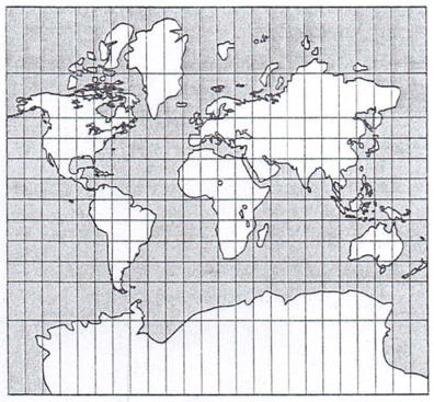
Invented by Flemish cartographer Gerardus Mercator for ships navigating across the Atlantic Ocean in 1569. The map is meant for direction, however, as a straight line is always a line of "constant compass bearing". The projection distorts sizes of areas, particularly as you get closer to the North and South poles. |
01 | 01 |
| metes and bounds | A property description that refers to physical features, directions and distances, to define the boundaries of a particular piece of land. Metes refers to a boundary defined by a measurement of a straight runs ("northeast 200 feet, then east 100 feet for example"), and bounds refers to a physical feature such as a waterway, wall, public road, or existing building. By contrast, see township and range. | 05 | |
| microstate | A state (country) that is extremely small. Monaco, Sao Tome, and Singapore are good examples of microstates. | 04 | |
| migration | A change in residence intended to be permanent | 02 | 06 |
| migration pattern |
|
02 | 06 |
| mineral fuels | Hydrocarbons, such as crude oil, which are not derived from current animal or plant sources‐also called "fossil fuels". | 05 | |
| mining | Extraction of valuable minerals or other geological materials from the Earth, usually from an ore body, vein, seam. Mining includes extraction of petroleum, natural gas, and water. | 05 | |
| monotheism | Monotheism this is the belief in one god. | 03 | |
| Mormonism | The religious, ideological, and cultural aspects of a number of denominations of the Latter Day Saint movement. Though there are Mormons around the world, there is a significant concentration of Mormons in the American West, principally in Utah. One of the requirements of Mormonism is a two-year mission, where young Mormons are sent to proselytize (seek converts) somewhere in the world. Many Mormons serve their two year mission in developing countries. | 03 | |
| mortality | There are two useful ways to measure mortality: infant mortality rate (IMR) and life expectancy. The IMR is the statistic that best represents a country’s health care system; and life expectancy measures the average number of years a baby can expect to live. | 02 | 01 |
| natality | see Crude Birth Rate | 02 | 06 |
| nation | A group of people who share a common history and culture—a nation of people. | 04 | |
| nation-state | A state (country) comprising a clearly delineated territory where the population shares a common history and culture (a nation of people). By contrast, there are many nations of people in the world who do not have a state of their own—so-called "stateless nations". | 04 | |
| national iconography | 04 | ||
| natural increase rate (NIR) |
The percentage by which a population grows in a year, without considering net-migration. It is calculated by the basic demographic equation:
CBR - CDR = NIR (excludes net migration) The NIR is used to calculate a population's doubling time, which is the number of years it will take to double a population. Related concepts are carrying capacity, dependency ratio. See also, Crude Birth Rate, Crude Death Rate. |
02 | 01 |
| natural landscape | The landforms, flora and fauna (which can include humans, we are, after all, fauna) that are present in a location or a space on Earth. By comparison, see cultural landscape | 01 | 06 |
| neocolonialism | Hegemonic control (economic, military, political, and social control) that MDCs have over LDCs. It is a criticism of economic development that is driven by MDCs: using supranational organizations such as the International Monetary Fund (IMF) and World Bank, MDCs dictate the terms and conditions that LDCs must meet to receive development assistance in the form of direct foreign investment. These investment funds, critics contend, burden the LDC to the point where the LDC might have been better-off not accepting them. | 06 | |
| neo-Malthusian | A contemporary theory that builds upon Thomas Malthus' thoughts on overpopulation—takes into account two factors that Malthus did not:population growth in LDC's, and depletion of resources other than food; recognizes that population growth in LDC's is from the transfer of STEM workers and technology rom MDC's but not the wealth that would provide food and resources | 02 | 06 |
| net migration | Immigration to a population cohort is an increase to that population's size. Emigration from a population cohort is a decrease in that population's size.
immigration - emigration = net migration |
02 | 06 |
| network | A set of interconnected nodes without a center. | 01 | 06 |
| network city |
|
07 | 06 |
| nomadic herding/pastorilism | Agricultural activity based on the herding of domesticated animals. | 05 | |
| non-renewable energy | Energy formed so slowly that for practical purposes it cannot be renewed. The three main mineral fuels (fossil fuels), petroleum, natural gas, and coal, plus nuclear fuels (uranium) are the most widely used. | 05 | |
| Notice To Mariners (NTM) | Reports important information concerning navigation, generally in coastal waters or major sea lanes to increase safety such as changes in channels, aids to navigation (markers and buoys), and so on. These reports assure that navigation maps, or sea charts, reflect current conditions. | 01 | 06 |
| Nunavut | 04 | ||
| Outback region of Australia | PG | 12 | |
| overpopulation | Relationship between the number of people on Earth, and the availability of resources. Problems result when an area’s population exceeds the capacity of the environment to support them at an acceptable standard of living.
See also, carrying capacity |
02 | 06 |
| Pampas of Argentina | PG | 03 | pattern | The repeated geometric arrangement of landforms and man-made objects across a space or over time. Some features are organized in a geometric pattern (tropical climate conditions occur in narrow bands of Earth's surface—between the Tropics of Cancer and Capricorn—but not necessarily regularly. Another example is the pattern of city streets, these are usually laid out according to a linear distribution, so that property sizes (and property values) are consistent. Whether natural or man-made, these patterns are generally closely related to a functional region, rather than a formal region. | 01 | 01 |
| perforated state | A state (country) that totally surrounds another state, South Africa. | 04 | |
| periodic movement | Movement that involves temporary, recurrent relocation (e.g., military service, migrant workers, college attendance, transhumance – movement of pastoralists and their livestock between highland and lowland pastures) | 02 | 06 |
| physical boundary (border) | Major physical features such as a deserts, mountain ranges, and/or water bodies that serves as a means of separation between countries or wiring countries. | 04 | |
| physiological density | The number of people per unit of area of arable land, which is land suitable for agriculture. | 02 | 01 |
| place | A distinctive space on the Earth. Its distinctiveness comes from its cultural landscapeas well as the people who currently live there.
| 01 | 01 |
| place name | Also called a toponym, it is the name given to a place on Earth. | 01 | 01 |
| planned economy | An economic system in which a government makes all decisions about the production and allocation of goods and services. Commonly used in which state or government controls the factors of production and makes all decisions about their use and about the distribution of income.
The Soviet Union and Communist China were the world’s largest planned economies, but each was forced to moving toward market-based economies to determine pricing, distribution, and production. Today most economies are market or mixed economies, except those in Cuba or North Korea. |
06 | |
| population density | See Crude Population Density. | 02 | XX |
| population distribution | The pattern of human settlement on the Earth’s surface. Geographers identify the three main properties as density, concentration, and pattern, but also clustered and dispersed to describe the world’s population. There are several major population concentrations:
|
02 | 01 |
| population explosion | A sudden increase or burst in the population in either a certain geographical area or worldwide. The first world-wide population explosion occurred in the late 18th and early 19th centuries as the industrializing nations of Europe and North America moved to Stage 2 of the Demographic Transition Model. Stage 2 of the DTM is graphically depicted by a age distribution graph (population pyramid) with a very wide base.
The post World War II "baby boom" (babies born in the years 1946-1964), was the last global population explosion. Another way to look at population explosion, however, is to consider that future projections of population grow exponentially, meaning that even at a constant rate of population growth, as the population gets larger, and ever-larger number of babies will be born in absolute terms. See also, J-Curve. |
02 | 01 |
| population policies | Government law intended to manage the size of a population. Expansive population policy encourages large families to raise the rate of population growth. Restrictive policy is intended to reduce the rate of natural increase. Examples include India’s sterilization program, China’s "one-child" law, and the eugenics policies of Nazi Germany. | 02 | 06 |
| population projection | A forward-looking prediction of population. Generally this is expressed in terms of a population's doubling time. See also, J-Curve. | 02 | 06 |
| possibilism | Possibilism is the belief that anything is possible ("Rosling: the seemingly impossible is possible") and that anything that is possible will be done (Friedman). It means that human knowledge, skills, and ability can (and will) make even harsh conditions on Earth, livable (thing air-conditioning!). Environmental Determinism is its opposite: conditions in the environment dictate what is possible. | 01 | 01 |
| primary economic activity | See economic sector. | 05 | |
| primate city |
AP07-2011APEXAMFRQ#1A-image.png |
07 | 06 |
| prorupt state | A state (country) having a portion of territory that is elongated making transportation and communications with that part of the country more difficult. India, Namibia, and Thailand are good examples of states with prorupt shapes. | 04 | |
| proselytic religion | Referred to as a Universalizing Religion, which is an attempt to be global, to appeal to all people, wherever they may live in the world, not just to those of one culture or location. There are three religions that practice this they are Christianity, Islam, and Buddhism. To proselytize is to try to convert another person to your religion. This important to HG because these are three of the biggest religions in the world they are practiced all over the world. | 03 | |
| pull factors | Attractions that draw migrants to a place (pleasant climate, employment, education). | 02 | 06 |
| Purchasing Power Parity (PPP) | Purchasing Power Parity (PPP) is an "adjustment" to a country’s GDP. Since GDP is a "price measure", PPP takes into account price differences between countries. Some goods and services in LDCs are priced lower than similar items in MDCs, so the PPP can make the income difference between LDCs and MDCs less. | 06 | |
| push factors | Incentives for people to leave a place, temporarily, or permanently (e.g., harsh climate, economic recession, political turmoil). | 02 | 06 |
| raison d’être | 04 | ||
| Rank Size Rule (Zipf) | Predicts the pattern of urban settlements (towns and cities) in many places in the developed world. If the largest town or city has a population of x, the second largest town will have a population of x/2, the 3rd largest will have a population of x/3 and so on. Under the rank-size rule, the rank of the city is the number in the denominator. (George Zipf, a linguist, first discovered the rank size rule by analyzing the way people use language: the word "the" is the most used English word; it is used twice as often as the second most frequently used word, "of". For a more detailed discussion, click here. | 07 | |
| Ravenstein's theory of migration |
Described in the 1880s by German-English cartographer Ernst Georg Ravenstein, it predicts that migration is a function of distance and different types of migrant, with women more likely than men to migrate within the country of their birth but less likely than men to leave the country of their birth.
| 02 | 06 |
| reapportionment | 04 | ||
| refugees | People who leave their homes because they are forced out or who seek better living conditions. Most refugees 1) move without any more tangible property than what they can carry or transport with them; 2) make their first “step” on foot, by bicycle, wagon, or open boat; and 3) move without official documents. | 02 | 04 |
| region | An area of Earth distinguished by a distinctive combination of cultural and physical features, such as a place, but generally over a large space. See also, cultural landscape. | 01 | 03 |
| regionalism | 04 | ||
| reincarnation | The idea of reincarnation is that after this life you will return to Earth. It is a core belief in Buddhism and Hinduism. Part of this belief is that one's actions in each life build or decrease one's karma; it is possible to return as a lower life form. | 03 | |
| relative location | Position on Earth's surface relative to other features. | 01 | 01 |
| relict boundary | A boundary that ceases to exist, however the imprint of the boundary still remains on the cultural landscape. The former East German border, East/West Berlin border and North/South Vietnam border are all examples of a relict boundary. | 04 | |
| religious architecture | There are architectural styles typical of world religions. For example, Christians have always made temples or churches, but many Christian groups have distinctive styles; a good example is whether or not a church steeple is adorned with a cross or not. Mormons do not generally use crosses, but Catholics almost always do. Hindus make many small shrines to their polytheistic gods, as do Buddhists. Muslim temples (mosques) generally feature one or several minarets (towers) one of which is used to call Muslims to prayer (a so-called "prayer tower"). Jewish temples will frequently feature a Star of David. Interior architecture can be regularized as well: Catholic cathedrals generally have a cross-shaped floor plan. Orthodox Jewish temples have separate seating for men and women. Each of these buildings contribute to a unique cultural landscape and a sense of place. | 03 | |
| religious boundary (border) | A boundary that was established principally to separate different religions, for example, Northern Ireland and the Republic of Ireland or the Israeli and Palestinian Authority borders. | 04 | |
| religion | A set of instructions for living that a group of people follow, generally attributed to the instructions of a single god (monotheism) or group of gods (polytheism). Major religious categories include universalizing religions, which seek converts (Christianity, Islam, Buddhism) and "ethnic religions" (Hinduism, Judaism, Confucianism, Shintoism). Within each of these religions, there are many different "sects", or sub-groups, that in a general sense adhere to a core set of beliefs and instructions but at the same time, have unique differences. | 03 | |
| religious conflict | Conflict, often violent, between groups of people who are followers of different religions between followers different sects within the same religion. One of the most significant is the ongoing Israeli-Palestinian conflict. The 9/11 Terrorist attacks and subsequent wars in Afghanistan and Iraq are also religious conflicts. Throughout human history, significant conflicts have either been caused by different religious beliefs or can be characterized as ethnic-religious conflicts: these include the Roman conquests, Muslim conquests, and the Christian crusades. | 03 | |
| relocation diffusion | The spread of an idea through physical movement of people from one place to another. Ex. spread of AIDS from New York, California, & Florida. | 01 | 02 |
| renewable energy | Energy replaced continually and has an essentially unlimited supply (it is not depleted when used by people). Solar energy, hydroelectric, geothermal, and wind, are the most widely used. Nuclear power (fission) is sometimes included. | 05 | |
| reunification | 04 | ||
| Rhine-Ruhr Valley of Europe | PG | 01F | rhumb-line | See line of constant compass bearing. A Mercator projection has straight rhumb lines and is therefore excellent for navigation, because compass courses are easy to plot and follow. | 01 | 01 |
| Rostow Stages of Growth Model |
Rostow's Stages of Growth Model is one of the major historical models of economic growth. It was published by American economist Walt Whitman Rostow in 1960. The model postulates that economic growth occurs in five basic stages, of varying length:
|
06 | |
| rural settlement | Sparsely settled places away from large cities. People live in villages, hamlets, on farms, or in other isolated houses. Typically these settlements have an economy based on logging, mining, petroleum, natural gas or tourism. Typically, there are two structures:
|
05 | |
| satellite state | 04 | ||
| S-Curve | Traces the cyclical movement upwards and downwards in a graph, specifically, the Demographic Transition Model. It is named for its shape as a horizontal letter "s": it is a feature of Stage 1 of the Demographic Transition Model. | 02 | 06 |
| sacred space | Sacred space is the place where religious figures and congregations meet to perform religious ceremonies. | 03 | |
| Sauer, Carl O. | Defined the cultural landscape as an area fashioned from nature by a cultural group. A combination of cultural features such as language and religion; economic features such as agriculture and industry; and physical features such as climate and vegetation. “Culture is the agent, the natural area is the medium, the cultural landscape is the result.” | 03 | |
| scale | Representation of a real-world phenomenon at a certain level of reduction or generalization. In cartography, the ratio of map distance to ground distance, indicated on a map as a bar graph, or representative fraction (ratio) is a map's scale. | 01 | 01 |
| scattered | See density. | 01 | 01 |
| Second Agricultural Revolution | Part of the industrial revolution in the 19th century, the Second Agricultural Revolution refers to a mechanization of agriculture. It required/enabled a shift of the work force from subsistence farming to manufacturing, beginning in United Kingdom, Netherlands, and Denmark, especially with the English Enclosure Act (which we discussed in the documentary film The Corporation) 1604. Also related is the so-called Columbian exchange, followed by the colonialism that brought new crops, such as potatoes, tomatoes, and corn, from the Americas to Europe, along with abundant gold and silver to feed the new global money economy. If you recall, this time period is what Thomas Friedman called Globalization 1.0 and Globalization 2.0. The first true global exchange of resources and manufactured goods. Also recall that Wallerstein chose 1648 as one of the "milestones" in his discussion of World Systems Theory. | 05 | Sector Model (Hoyt, 1939). | Focuses on residential patterns explaining where the wealthy in a city choose to live. Hoyt argued that a city grows outward from its center, so a low-rent area could extend all the way from the CBD to the city's outer edge, creating zones which are shaped like pieces of a pie. Compare to the Concentric Zone Model (Burgess, 1925). | 01 | 01 |
| secularism | The belief that human affairs should be governed by a social contract rather than religious beliefs. The so-called "separation of church and state" in the US is a good example of secularism. | 03 | |
| self-determination | 04 | ||
| sex ratio | The number of males per hundred females in the population. | 02 | 02 |
| sequent occupance (sequent occupancy) | The notion that successive societies leave their cultural imprints on a place, each contributing to the cumulative cultural landscape.The notion that successive societies leave their cultural imprints on a place, each contributing to the cumulative cultural landscape. Good examples, would include historic buildings or other spaces such as parks, dredged ports and canals, road networks, and so on. These things are often still used for their original purpose, but may have been substantially changed. | 01 | 03 |
| Serengeti | PG | ||
| shamanism | An ancient animistic belief that a special person (the shaman, or priest) can conjure or channel a god to allow people to consult directly with that god concerning a certain circumstance. Sometimes, the shaman is asked to provide a connection to a god to cure, or heal, and, in some cases, cause pain to people. Voodoo is a shamanistic belief system. Shamanism is common in Africa and places where Africans were dispersed by the slave trade. | 03 | |
| sharia law | It is the legal framework within which public and private aspects of life are prescribed by a strict interpretation of the Koran in fundamentalist Muslim society. | 03 | |
| shatterbelt | 04 | ||
| shifting cultivation | An agricultural system in which plots of land are cultivated temporarily, then abandoned. This system often involves clearing of a piece of land followed by several years of farming until the soil loses fertility. Once the land becomes inadequate for crop production, it is left to be reclaimed by natural vegetation. Then the process can be repeated. This system of agriculture is often practiced at the level of an individual or family, but sometimes may involve an entire village. There are a few approaches, depending on the natural environment: wood harvesting (timbering) and stump removal; slash-and-burn (slashing trees and shrubs to dry them, then burning the plot); and land clearing without any burning (typical where grasses are the natural vegetation). Often, these practices leave soils that are near exhaustion. | 05 | |
| Shintoism | The native religion of Japan and once its state religion. It involves the worship of kami (a god). Today, Shintoism is generally a cultural, rather than a religious phenomenon. Most Japanese, for example, wish to have a Shinto wedding, or occasionally perform Shinto rituals, but they do not do so because they believe that a god or gods require them to do so. | 03 | |
| Sikhism | A religion that began in fifteenth century Northern India. The principal emphasis of Sikhs is equality, and they accept that truths can be learned from all religions. An emphasis is to face everyday problems according to their principles taught by the wise (guru). | 03 | |
| site | The physical character of place; what is found at the location and why it is significant. | 01 | 01 |
| situation | The location of a place relative to other places. | 01 | 01 |
| size | Is the estimation or determination of extent. | 01 | 01 |
| sovereignty | 04 | ||
| Socioeconomic Status | From wikipedia:
Socioeconomic status (SES) is an economic and sociological combined total measure of a person's work experience and of an individual's or family's economic and social position in relation to others, based on income, education, and occupation. When analyzing a family's SES, the household income, earners' education, and occupation are examined, as well as combined income, versus with an individual, when their own attributes are assessed. |
06 | 01 | space-time compression | The reduction in the time it takes to diffuse something to a distant place, as a result of improved communications and transportatio system | 01 | 01 |
| Spatial Analysis Tradition |
From WD Pattison's Four Traditions of Geography:
|
01 | 01 |
| spatial distribution | Physical location of geographic phenomena across space. | 01 | 01 |
| spatial interaction | One of the Four Traditions, and Five Themes of geography, spacial interaction (or spatial analysis) invokes the concepts of accessibility, connectivity, network, distance decay (friction of distance) and time-space compression. | 01 | 01 |
| specialization of labor |
Before the first agricultural revolution, people lived in small groups (bands, clans, tribes). Families would do all of the things they needed to survive (hunting and gathering, tool making, pottery and cloth making, constructing shelters.
When these smaller groups either found or developed an agricultural system that provided surplus foods, they could settle in one place and begin share the work of survival. Individuals or families no longer needed to learn how to do every kind of work, instead, they would specialize: make or do more of one thing than they or their family needed, and trade the surplus to someone who was doing something else; so, for example, one person could specialize in making pottery, while another could specialize in baking bread. As a result of this specialization, people were able to get better and better at a particular skill and the quality of production improved and standards of living increased. Of course, specialization continues in the modern world, but we use different terms such as "division of labor", "global division of labor", "international division of labor" to describe these ever more complex relationships and in general terms, this is the goal of economic development. |
06 | 07 |
| standard of living | A measure of the quality and quantity of goods and services available to people and the way they are distributed within a population. Higher standards of living are found in MDC's rather than LDC's. See also, Socioeconomic Status (SES) | 06 | 01 |
| state | A political entity that maintains status as an independent country. | 04 | |
| stateless ethnic group/stateless nation | 04 | ||
| staple grains | Maize (corn), wheat, and rice are the most commonly harvested grains world wide, accounting for almost 90% of all grains and close to 50% of all food (see calorie consumption. Corn and corn products are staple foods of the Americas and the most important feed for livestock worldwide. Wheat is primarily consumed in temperate regions (North America and Europe), and rice in tropical regions worldwide. | 05 | |
| subsequent boundary (border) | Boundaries that are created as a result of long term processes. | 04 | |
| subsoil | Below the surface of Earth. Boundaries are vertical planes not merely lines on a map and extend, theoretically, to the center of the Earth. The right to mine or otherwise use subsoils are an aspect of sovereignty. | 04 | |
| step migration | Migration to a destination that occurs in stages (e.g., from farm to nearby village and later to town and city). | 02 | 06 |
| suffrage | 04 | ||
| suitcase farm | People who live in urban areas a distance from their fields and drive to the country to care for their crops and livestock. This practice is typical of wheat farming and it allows families to continue their long relationships with the ancestral farm, but still enjoy the benefits of a wage income in a city. | 05 | |
| superimposed boundary (border) | A boundary that has been forced upon the inhabitants of an area to solve a problem and/or conflict. The Israeli and Palestinian Authority border is a good example of a superimposed boundary. | 04 | |
| supranationalism | 04 | ||
| sustainable yield | An amount of extraction sector activity that does not reduce a given resource below a certain base level. For example, in fisheries, forestry, agriculture there is some level of extraction that can be sustained over time that does not further reduce a fish species’ breeding stock; does not expand the harvesting of trees further than current levels of timbering-cutting; or does not deplete soils beyond what can be profitably replenished. | 05 | |
| sustainability (sustainable development) | Sustainable development meets today’s needs without compromising the ability of future generations to meet their own needs. | 02 | 06 |
| technology gap | The difference in technologies used and/or developed in two companies, countries, ethnic groups, etc., where one is more advanced than the other. | 06 | |
| technology transfer |
The process by which existing knowledge, facilities, or capabilities developed in one company, country, or place move to another company, country, or place.
This is a key development strategy for many LDCs. In some cases, entire factories or other complete technological systems are purchased from MDCs and brought to LDCs. |
06 | |
| territorial disputes | 04 | ||
| territorial morphology (compact, fragmented, elongated, prorupt, perforated) | 04 | ||
| territoriality | 04 | ||
| theocracy | 04 | ||
| third-world country | This term for under-developed countries is generally no longer used in academic works, but still commonly encountered elsewhere. See Less Developed Country (LDC). | 06 | |
| time zone |
Because the Earth is a sphere, meaning 360°, and because the Earth spins once every 24 hours, each 15° line of longitude divides the world into an hour of time (360 ÷ 15 = 24). The map shows the world's time zones, there are 24, of course, and each is expressed as "plus" or "minus" Greenwich Mean Time (GMT), which is 0° longitude, or the prime meridian. So, India is GMT +5 (meaning that it is five hours later in the day in India than it is in London, England (Greenwich is a part of Greater London). Miami, on the other hand, is GMT -5 (meaning that it is five hours earlier in the day than it is in London).
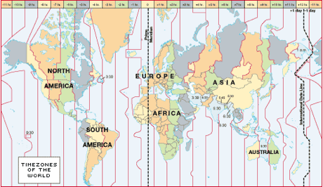
|
01 | 06 |
| toponym | Also called a toponym, it is the name given to a place on Earth. | 01 | 01 |
| Total Fertility Rate (TFR) |
(TFR) average number of children born to a woman during her childbearing years (expressed as children per woman). In general terms, a TFR of 2.1 means that a population is not growing larger—the population’s rate of natural increase (RNI or NIR) is zero (which is called zero population growth, or "ZPG".
|
02 | 06 |
| township-and-range | A grid-like land division in US midwestern states west of Ohio after the purchase of the Louisiana Purchase. Land is divided into six-mile square blocks (township), which is then divided into one-mile square blocks (range). The 640 acre square ranges were then broken into smaller parcels (40 acres commonly). By contrast, see metes and bounds. | 05 | |
| tragedy of the commons | A social-economic trap that involves a conflict over resources between private interests and the common good. There was a game on the web called the Tragedy of the Bunnies that demonstrated this concept well. Its no longer active, but you can try to play it on the WayBackMachine at the following URL: http://web.archive.org/web/20140208053932/http://bunnygame.org/ | 05 | |
| transhumance | Pastoral practice of seasonal migration of livestock between mountains and lowland pasture areas. | 05 | |
| treaty | 04 | ||
| treaty port | 04 | ||
| truck farming | Commercial gardening and fruit farming, so named because truck was a Middle English word meaning bartering or the exchange of commodities. Predominant in Southeastern US, because of the long growing season and humid climate, accessibility to large markets of New York, Philadelphia, and Washington. Truck farms grow many of the fruits and vegetables that consumers demand in developed societies. Truck farms sell some of their product to fresh markets, but mostly to large processors for canning or freezing. Truck farms are highly efficient and large-scale operations that take full advantage of machines at every stage of the growing process. | 05 | |
| underpopulation | As a result of a sharp drop or decrease in a region’s population, there are no longer a sufficient number of people to support the local economic system. | 02 | 06 |
| unitary | 04 | ||
| United Nations | 04 | United Nations Convention on the Law of the Sea (UNCLOS) | 04 |
| USSR collapse | 04 | ||
| vernacular region | Also called a perceptual region, is a place that people believe exists as a part of their cultural identity. Such regions emerge from peoples informal sense of place rather than from scientific models developed through geographic thought. Often identified using a mental map—which is an internal representation of a portion of Earths surface. | 01 | 01 |
| voluntary migration | Movement in which people relocate in response to perceived opportunity. | 02 | 06 |
| von Thunen, Johann Heinrich | Published an early complete analysis of agricultural production in 1828, titled The Isolated State. A commercial farmer compares the cost of land and the cost of transportation to market (both distance and special considerations like weigh or perishability) to determine which agricultural crop can be sold at a profit. He also noted that specific crops were grown in varying rings around city. Market-oriented gardens and milk producers in first ring, because of expense of transportation and perishability. In the next rings wood lots used for construction and fuel, because it is a heavy industry with high transportation costs. Next rings are used for various crops or pasture, with the outermost ring devoted to animal grazing. Von Thunen’s theory disregards site or human factors. | 05 | 06 |
| women’s enfranchisement | Granting the right to vote to women. See also, suffrage. | 04 | |
| World-systems Theory | "World-system" refers to the inter-regional and transnational division of labor, which divides the world into core countries, semi-periphery countries, and the periphery countries. Core countries focus on higher skill, capital-intensive production, and the rest of the world focuses on low-skill, labor-intensive production and extraction of raw materials. This constantly reinforces the dominance of the core countries. Nonetheless, the system has dynamic characteristics, in part as a result of revolutions in transport technology, and individual states can gain or lose their core (semi-periphery, periphery) status over time. For a time, some countries become the world hegemon; during the last few centuries, as the world-system has extended geographically and intensified economically, this status has passed from the Netherlands, to the United Kingdom and (most recently) to the United States of America. source: wikipedia World-systems Theory is closely associated with Immanuel Wallerstein. It seeks to explain the “capitalist world economy” as a “total social system”. See also, core-periphery model. | 06 |