Chapter 1: Major Geographical Concepts
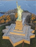
If you are here, where in the world are you? New York City? Yes, but more specifically, where are you? There are a number of ways to describe your location if you are where the photograph of the Statue of Liberty was taken. Clearly, the photographer was over, substantially over, the Statue of Liberty, which is located on Liberty Island in New York Harbor, New York City.
1A: Pattern & Process
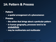
Pattern
- a spatial arrangement of a phenomenon
- maps present a spatial pattern of different phenomena at any give time
- the features on a map, landforms or man-made, are called attributes by Malinowski—this is not a word specific to AP Human Geography, but it is useful as a label to differentiate the way people think about places:
- cities, towns, unincorporated areas
- rivers, lakes, coastlines
- transportation networks (roads, railroads, ports, airports—"transportation infrastructure")
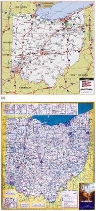
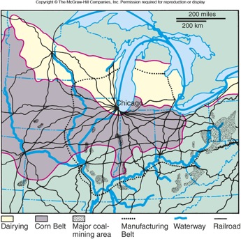
- the roadmaps of Ohio in the textbook reveal different attributes—they are separated by 50 years or so
- interstate highways vs. "secondary roads"
- road maps in Europe look like the older map of Ohio
- what processes have led to the changes
- people often conceptualize a place in a different way than merely thinking of the attributes of a place
- attitudes of people, for example aren't generally presented on a map
- an idea can be gleaned from considering things like religious sites, academic sites, or entertainment venues
- this is one of the the regionalization processes (see "vernacular region", below)
Process
- defined: action(s) that bring(s) about a particular pattern
- in human geography, processes are less "deterministic" (meaning that the outcome is guaranteed) and are more likely to be "probabilistic" (likely to occur)
- multivariate (many processes are at work simultaneously)
- multiscalar (processes are at work on different scales)
- what happens when a new highway is to be built?
- how will it change the landscape at different scales of analysis?
- how will the highway it affect neighborhoods (good/bad)?
- how will the highway affect regional traffic patterns?
- how will the highway affect future land development projects?
Pattern and Process—Electoral Politics
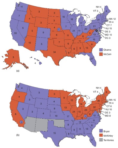
Political Geography is a "cognate", or related, discipline. These two maps are the electoral college maps from the US presidential elections in 1896 (Bryan/McKinley) and 2008 (Obama/McCain).
What patterns are discernible from these two electoral maps?
- Red = Republican
- Blue = Democrat
- the pattern is almost flipped—what is the cause?
- the number of electoral college votes each state has changes—why?
- will that pattern continue to change? are the processes the same?
1B: Absolute & Relative Location
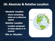
Absolute Location
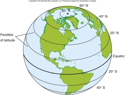
- where something exists on a reference system—usually a grid of some kind
- the globe shows lines of latitude
- lines of latitude are arbitrary and superimposed
- the Equator divides the globe (sphere) into hemispheres
- starting with 0°, lines of latitude count upwards to 90° both north and south
- the poles are at 90°
- lines of latitude are parallel to one another
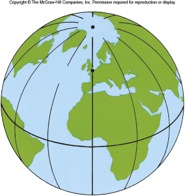
- adding lines of longitude results in a grid pattern
- adding lines of longitude results in a grid, or geographical coordinate system
- lines of longitude are arbitrary and superimposed
- lines of longitude are generally presented in increments of 15°
- 360° ÷ 24 hours = 15°
- each 15° is one hour of the Earth's rotation
- international time zones align (in most cases) with lines of longitude
- 0° is located over Greenwich, England (London)
- 180° is the continuous line of longitude passing over Greenwich
- 180° is also the "international date line"—when the international date line passes under the sun, its a new day
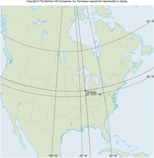
- the city of Chicago is located at 42°North Lattitude 87°West Longitude, or 42°N 87°
Relative Location
- Location compared to other places or in context
- example: a new factory's location might be proposed based on the location of resources (labor, natural resources, transportation routes)
Site vs. Situation
- site is a way to describe a specific location's forms and features, both natural and manmade
- Miami's site would include its skyline, noteworthy public spaces, districts, monuments, and so forth
- situation is a way to describe a specific location by reference to the things that surround it
- Miami is situated on the southeast tip of the Florida peninsula centered at the mouth of the Miami River
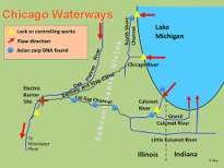
Chicago's Relative Location
The city of Chicago underwent rapid expansion in the 19th century—it is a good example of the benefits of centrality.
Chicago's Site and Situation
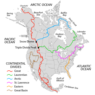
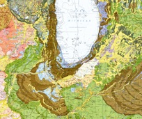
- the city is situated on a natural harbor at the southern end of Lake Michigan
- the city straddles a gap in the Valparaiso Moraine (shown in the images to the right) called the "Chicago Portage"
- a portage is a low-lying area in a barrier between two different watersheds, in this case, the Valparaiso is part of the St Lawrence subcontinental divide>
- the St Lawrence Divide divide separates the Great Lakes (Lake Michigan) from the Mississippi
- rainfall along the St Lawrence divide will flow either east into the Great Lakes OR west into the Mississippi
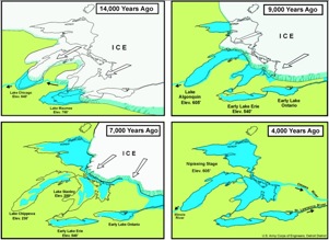
- terminal moraines, like the Valparaiso Moraine, were deposited by glaciers
- during the last glaciation—the Wisconsin Glaciation (20,000 YBP)—rocks were scraped up and pushed southward as the glaciers grew
- when the glaciers melted and receded, they left behind immense piles of often immense rocks
- the Chicago portage has at times been submerged—connecting the Great Lakes with the Mississippi
- the Chicago Portage has been dry for the past several thousand years
- before Europeans arrived in North America, the Chicago Portage was the key strategic point of the entire northwest
- Native Americans would carry their canoes just a few kilometers over marshes to cross the divide
- Chicago has been a central point of the Great Lakes system of commerce (trade and communication) and a vital link in the US economy for over 150 years
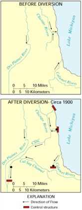
- canals connected Lake Michigan and the Mississippi River in the 19thcentury
- the Erie Canal (1824) connected the Hudson River with the Great Lakes
- the Illinois and Michigan Canal (1848) connected Lake Michigan with the Mississippi River
- in 1900 the Illinois and Michigan was replaced by the created the Chicago Sanitary and Ship Canal (also called the "Chicago Drainage Canal")
- reversed the flow of the Chicago River
- did not want to pollute Lake Michigan
- pollution flows into Mississippi
- must stop the wastewater flow within a few years by law
- railroads followed after the Civil War
- refrigeration (refrigerated rail cars) and manufactured ice accelerated trade in foods
- Chicago became the center of commodities trade with the east (Chicago Board of Trade)
- Chicago is a megalopolis: 10 million population
- it is a sophisticated economy in all sectors (extraction, manufacturing, services)
1C: Place & Space
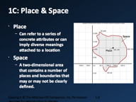
Place
- Can refer to a series of concrete attributes or can imply diverse meanings attached to a location
Space
- A two-dimensional area that contains a number of places and boundaries that may or may not be clearly defined.
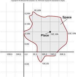
Note: This figure is intended to help you identify place attributes and their relative significance. Ignore it. Its something only this textbook uses.
1E: Mapping Spatial Distributions
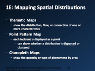
Thematic Maps
- show the distribution, flow, or connection of one or more characteristics
Point Pattern Map
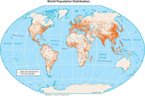
- each incident is displayed as a point
- can show whether a distribution is dispersed or clustered
- example shows world population distribution: one dot = 100,000 people
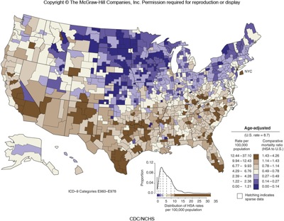
Choropleth Maps
- show the quantity or type of phenomena by area
- the example is homicides per 100,000 population
1F: Spatial Interactions & Distance
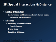
Spatial Interaction
- patterns result from relationships between places
- place interaction: movement of people, goods and services, ideas (communications)
- spatial interaction: connectivity, accessibility, both physical (roads, e.g.) or electronic (internet, broadcast, cable, phone)
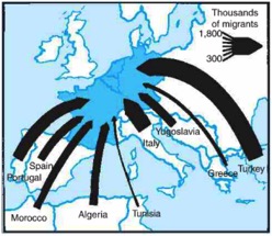
- a "flow map" is useful to show interactions between places—the example shows migrant workers: how many, from where, to where?
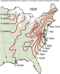
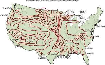
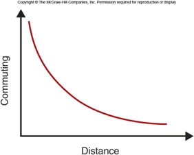
- absolute distance vs travel distance vs travel time (technology, infrastructure)
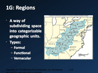
1G: Regions
Defined
- place similarity and place interaction (implies proximity)
- two or more places with a spatial dimensionality (implies continuity)
- also implies boundary of some kind,/li>
A way of subdividing space into categorizable geographic units
Types:
- Formal Regions
- composed of places that have one or more characteristics in common
- physical: elevation, climate, soil, rock formations, topography, vegetation, crops, land use (rural or urban)
- cultural: population, ethno-linguistic groups, religion, education, political groups, socioeconomic status
- economic: businesses and industry
- Functional
- Regions constructed out of places that interact.
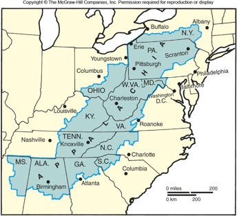
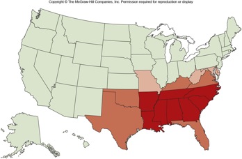
Vernacular Regions
Regions that people construct in their mind.
The image to the right shows what people call the "deep South" or "Dixie" in the southeastern US
It is also a choropleth map—the colors mean something:
- red states:
- orange states:
- pink-ish states:
1H: Idea of Landscape
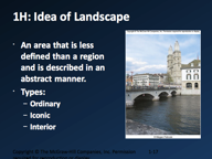
Defined: An area that is less defined than a region and is described in an abstract manner.
Better: land, German origin, means land; scape: English origin, means shaping—even landscape paintings are an example since they are land presented to the viewer as the artist renders it
Types:
- ordinary: people going about their daily lives, changing the Earth as a result (simplest: paths, most complex: skyscrapers)
- iconic: images and symbols, monuments—the landscape as an expression of identity
- interior: inside buildings or other structures—expressions of identity at different scales, from homes to the inside of public structures